Mysteries of Area 51... Groom Lake ... Dreamland
 |
Area 51 is a nickname for a military base located in the southern portion of Nevada in the western United States (83 miles north-northwest of downtown Las Vegas). Situated at its center, on the southern shore of Groom Lake, is a large secretive military airfield. The base's primary purpose is to support development and testing of experimental aircraft and weapons systems.
The base lies within the United States Air Force's vast Nevada Test and Training Range. Although the facilities at the range are managed by the 99th Air Base Wing at Nellis Air Force Base, the Groom facility appears to be run as an adjunct of the Air Force Flight Test Center (AFFTC) at Edwards Air Force Base in the Mojave Desert, around 186 miles (300 km) from Groom, and as such the base is known as Air Force Flight Test Center (Detachment 3).
Other names used for the facility include Dreamland, Paradise Ranch, Home Base, Watertown Strip, Groom Lake and most recently Homey Airport. The area is part of the Nellis Military Operations Area, and the restricted airspace around the field is referred to as (R-4808N), known by the military pilots in the area as The Box.
|
The intense secrecy surrounding the base, the very existence of which the U.S. government barely acknowledges, has led it to become the frequent subject of conspiracy theories and a central component to unidentified flying object (UFO) folklore.
Operations at Groom Lake
Groom Lake is not a conventional airbase, and front-line units are not normally deployed there. It appears, rather, to be used during the development, test and training phases for new aircraft. Once those aircraft have been accepted by the USAF, operation of that aircraft is generally shifted to a normal airforce base. Groom is reported, however, to be the permanent home for a small number of aircraft of Soviet design (obtained by various means). These are reportedly analysed and used for training purposes.
Soviet spy satellites obtained photographs of the Groom Lake area during the height of the Cold War, but these support only modest conclusions about the base. They depict a nondescript base, airstrip, hangars, etc., but nothing that supports some of the wilder claims about underground facilities. Later commercial satellite images show the base has grown, but remains superficially unexceptional.
Senior Trend / U-2 program
Groom Lake was used for bombing and artillery practice during World War II, but was then abandoned until 1955, when it was selected by Lockheed's skunkworks team as the ideal location to test the forthcoming U-2 spyplane. The lakebed made for an ideal strip to operate the troublesome test aircraft from, and the Emigrant Valley's mountain ranges and the NTS perimeter protected the secret plane from curious eyes.
Lockheed constructed a makeshift base at Groom, little more than a few shelters and workshops and a small constellation of trailerhomes to billet its small team in. The first U-2 flew at Groom in August of 1955, and U-2s under the control of the CIA began overflights of Soviet territory by mid-1956.
During this period, the NTS continued to perform series of atmospheric nuclear explosions. U-2 operations throughout 1957 were frequently disrupted by the Plumbbob series of atomic test, which exploded two dozen devices at the NTS. The Plumbbob-Hood explosion scattered fallout across Groom and forced its (temporary) evacuation.
As U-2's primary mission was to overfly the Soviet Union, it operated largely from airbases near the Soviet border, including Incirlik in Turkey and Peshawar in Pakistan.
Blackbird (OXCART / A-10 / A-11 / A-12 / SR-71) program
Even before U-2 development was complete, Lockheed began work on its successor, the CIA's OXCART project, a Mach-3 high altitude reconnaissance aircraft later known as the SR-71 Blackbird. The blackbird's flight characteristics and maintenance requirements forced a massive expansion of facilities and runways at Groom Lake. By the time the first A-12 Blackbird prototype flew at Groom in 1962, the main runway had been lengthened to 8500 ft (2600 m) and the base boasted a complement of over 1000 personnel. It had fueling tanks, a control tower, and a baseball diamond. Security was also greatly enhanced, the small civilian mine in the Groom basin was closed, and the area surrounding the valley was made an exclusive military preserve (where interlopers were subject to "lethal force"). Groom saw the first flight of all major Blackbird variants: A-10, A-11, A-12, RS-71 (renamed SR-71 by USAF Chief of Staff Curtis LeMay and not by a presidential error as popularly believed), the abortive YF-12A strike-fighter variant, and the disastrous D-21 Blackbird-based drone project.
Have Blue / F-117 program
The first Have Blue prototype stealth fighter (a smaller cousin of the F-117) first flew at Groom in late 1977. Testing of a series of ultra-secret prototypes continued there until mid-1981, when testing transitioned to the initial production of F-117 Nighthawk stealth fighters. In addition to flight testing, Groom performed radar profiling, F-117 weapons testing, and was the location for training of the first group of frontline USAF F-117 pilots. Subsequently active-service F-117 operations (still highly classified) moved to the nearby Tonopah Test Range, and finally to Holloman Air Force Base.
Later operations
Since the F-117 became operational in 1983, operations at Groom Lake have continued unabated. The base and its associated runway system have been expanded, and daily flights bringing civilian commuters from Las Vegas continue. Some commentators, after examining recent satellite photos of the base, estimate it to have a live-in complement of over 1000 people, with a similar number commuting from Las Vegas. In 1995 the federal government expanded the exclusionary area around the base to include nearby mountains that had hitherto afforded the only decent overlook of the base.
Rumored aircraft that have supposedly been tested at Groom include the D-21 Tagboard drone, a small stealthy VTOL troop-transport aircraft, a stealthy cruise missile, and the hypothetical Aurora hypersonic spyplane.
Area 51 Commuters
Defense contractor EG&G maintains a private terminal at McCarran International Airport in Las Vegas. A number of unmarked aircraft operate daily shuttle services from McCarran to sites operated by EG&G in the extensive federally-controlled lands in southern Nevada. These aircraft reportedly use JANET radio callsigns (e.g. "JANET 6"), said to be an acronym for "Joint Air Network for Employee Transportation" or, (perhaps as a joke) "Just Another Non-Existent Terminal". EG&G advertises in the Las Vegas press for experienced airline pilots, saying applicants must be eligible for government security clearance and that successful applicants can expect to always overnight at Las Vegas. These aircraft, painted white with a red trim, include Boeing 737s and several smaller executive jets. Their tail numbers are registered to several unexceptional civil aircraft leasing corporations. They are reported to shuttle to Groom, Tonopah Test Range, to other locations in the NAFR and NTS, and reportedly to Naval Air Weapons Station China Lake. Observers counting departures and cars in the private EG&G parking lot at McCarran estimate several thousand people commute on JANET each day.
A chartered bus (reportedly with whited-out windows) runs a commuter service along Groom Lake Road, catering to a small number of employees living in several small desert communities beyond the NTS boundary (although it is not clear whether these workers are employed at Groom or at other facilities in the NTS).
The Government's position on Area 51
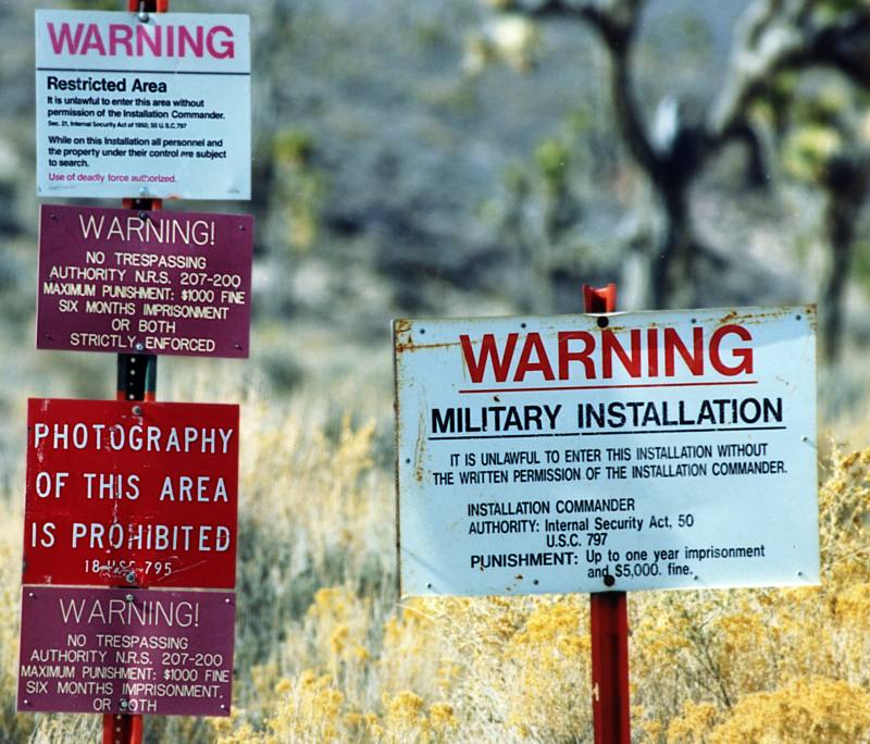
The U.S. Government does not explicitly acknowledge the existence of the Groom Lake facility, nor does it deny it. Unlike much of the Nellis range, the area surrounding the lake is permanently off-limits both to civilian and normal military air traffic. The area is protected by radar stations, buried movement sensors, and uninvited guests are met by helicopters and armed guards. Should they accidentally stray into the exclusionary "box" surrounding Groom's airspace, even military pilots training in the NAFR are reportedly grilled extensively by military intelligence agents.
The base does not appear on public US government maps; the USGS topological map for the area only shows the long-disused Groom Mine, and the civil aviation chart for Nevada shows a large restricted area, but defines it as part of the Nellis restricted airspace. Similarly the National Atlas page showing federal lands in Nevada doesn't distinguish between the Groom block and other parts of the Nellis range. Although officially declassified, the original film taken by US Corona spy satellite in the 1960s have been altered prior to declassification; in answer to freedom of information queries, the government responds that these exposures (which map to Groom and the entire NAFR) appear to have been destroyed (Corona image). Terra satellite images (which were publicly available) were removed from webservers (including Microsoft's "Terraserver") in 2004 ( Terraserver image), and from the monochrome 1m resolution USGS datadump made publically available. NASA Landsat 7 images are still available (these are used in the NASA World Wind program and are displayed by Google Maps). In Non-US images, including high-resolution photographs from Russian satellites and the commercial IKONOS system are also easily available (and abound on the Internet).
In response to environmental and employee lawsuits (including a class-action lawsuit brought by employees of the base for toxic waste exposure), a Presidential Determination is issued annually, exempting the Air Force's Operating Location Near Groom Lake, Nevada from environmental disclosure laws (2002 determination, 2003 determination). This (albeit tacitly) constitutes the only formal recognition the US Government has ever given that Groom Lake is more than simply another part of the Nellis complex.Nevada's state government, recognising the folklore surrounding the base might afford the otherwise neglected area some tourism potential, officially renamed the section of Nevada Highway 375 near Rachel "The Extraterrestrial Highway", and posted fancifully-illustrated signs along its length.Interlopers discovered on (or, some say, near) the restricted area are generally detained by armed private security guards (reportedly employees of defence contractor EG&G) and are then handed over to the Lincoln County sheriff.
Modest fines (of around $600) seem to be the norm, although some visitors and journalists report receiving follow-up visits from FBI agents.Although federal property within the base is exempt from state and local taxes, facilities owned by private contractors are not. One researcher has reported that the base only declares a taxable value of $2 million to the Lincoln County tax assessor, who is unable to enter the area to perform an assessment. Some Lincoln County residents have complained that the base is an unfair burden on the county, providing few local jobs (as most employees appear to live in or near Las Vegas) an iniquitous burden of land-sequestration and law-enforcement costs.
UFO and conspiracy theories concerning Area 51
the storage, examination, and reverse-engineering of crashed alien spacecraft (including material supposedly recovered at Roswell), the study of their occupants (living and dead), and the manufacture of aircraft based on alien technology. Bob Lazar claimed to have been involved in such activities.meetings or joint undertakings with extra-terrestrials.the development of exotic energy weapons (for SDI applications or otherwise) or means of weather control.activities related to a supposed shadowy world government.Some claim an extensive underground facility has been constructed at Groom Lake (or nearby Papoose Lake) in which to conduct these activities.
* meetings or joint undertakings with extra-terrestrials
* the development of exotic energy weapons (for SDI applications or otherwise) or means of weather control
* activities related to a supposed shadowy world government
Some claim an extensive underground facility has been constructed at Groom Lake (or nearby Papoose Lake) in which to conduct these activities.
Most Detailed Images Ever of Top-Secret U.S. Air Base Show Major Expansion
space.com
Detailed images of Area 51 just released may not show evidence of little green men, but they do show that the super-secret Air Force base has grown significantly over the years.
"I want to see flying saucers as much as anyone," said Federation of American Scientist¹s John Pike, who ordered the 1-meter (3.2-foot) images, the most detailed to date, from Thorton, Colorado-company Space Imaging. Instead, the photos -- captured over the past few months -- show that the area has significantly expanded since the first images were snapped of the infamous site over 30 years ago.
"It¹s interesting to contemplate what is going on there. It seems as though there is tons of money going in there and nothing is going out," he said.
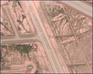
Runway at Area 51
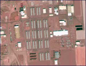
The barracks - home of people who live on the base
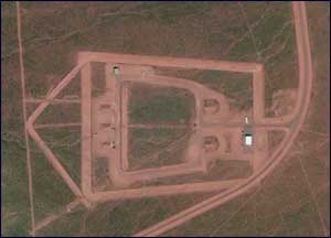
The munitions storage area
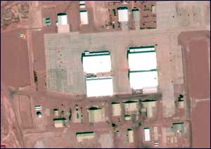
The aircraft hangar
And four aircraft hangars are visible off the runway. Conspiracy theorists have long believed that one of these hangars, dubbed Hangar 18, is the holding area for the alien bodies and captured alien technology taken from crash sites.
These high-resolution images, captured by Space Imaging¹s IKONOS satellite on April 2, were released less than a week after Raleigh, North Carolina-based Aerial Images unfolded its series of 6.6-foot (2-meter) photos of the mysteriously secretive area over the Web, crashing the site for days.
Though the public's ravenous appetite for these images was made obvious this past week, Pike¹s purpose for getting these photos was different.
Pike said the request was a test to see how long it would take to gain access to these images and how they may be used by military agencies around the world.
"This is an interesting case study that enables us to explore in practical rather than theoretical terms just what is this 'Brave New World' we¹ve entered into."
This so-called 3.3-foot (1-meter) resolution technology once was available only to intelligence agencies through their own spy satellites. But it has been estimated that by the year 2003, at least 11 companies in five countries will have high-resolution, remote-sensing cameras in orbit.
That sort of commercial technology in space worries government officials because they believe such detailed imagery could encourage industrial espionage, terrorism or more cross-border military attacks in the developing world.
But Pike seemed unfazed by the impact of this imagery on national security.
Because it took 2 months to get the images, he said the technology would only be useful during peacetime for monitoring specific regions instead of during wartime, when the military may need to target a strategic area.
"The war may already be over before you get your picture," Pike said.
Space Imaging's Mark Brender argued that obtaining images doesn't always take so long. "We can turn stuff around in 24 hours," he said. When twin tornadoes touched down in Texas on March 28, for example, Brender says that within a few hours they were evaluating the images and ready to release them to the public within 24 hours.
"We can produce images very shortly for natural disasters and crisis, " he said.
Area 51 -- 75 miles (121 kilometers) northwest of Las Vegas occupies about 150 square miles (390 square kilometers) of a dried up lakebed in the Great Basin Desert, Nevada. It was named after the grid it occupies on an old Nevada map and came into existence in 1955 when aerospace company Lockheed Martin landed there to test the U 2, a high-altitude surveillance plane.
The top-secret base later became a proving ground for several generations of high-tech prototypes, including the F 117-A Stealth fighter.
The shroud of secrecy thickened once the Air Force bought up about 9,000 acres of land around the base to prevent the public from getting too close. In August 1994, an Air Force official admitted the base existed, saying the Air Force has "facilities within the complex near the dry lakebed of Groom LakeŠused for testing, training technologies, operations and systems critical to the effectiveness of U.S. military forces."
Ufologists have long believed that unidentified flying objects from other planets are entrenched in underground bases in the region and insist alien autopsies are being conducted there. But, conventional wisdom says the base is likely a center for super-secret operations dealing with sophisticated military aircraft.

Discuss article |
Article Link
|
More unsolved mysteries on Unexplained Mysteries
|